KATRINA / An Unpredictable Behemoth Grew
ANDREW C. REVKIN The New York Times
Approaching Storm Slows Oil Output in Gulf of Mexico (NYT)
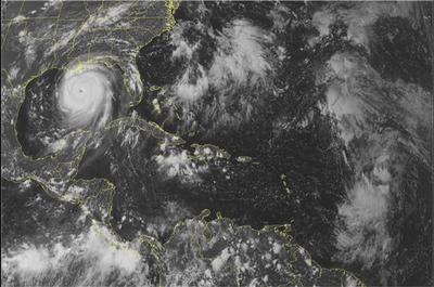
As ripples of vapor-filled turbulence began to organize into a storm over the steamy waters of the southeastern Bahamas early last week, Tropical Depression 12 was born, giving few hints that it was an embryonic monster that would grow into Hurricane Katrina.
In the 5 p.m. written "public discussion" on Tuesday, forecasters at the National Hurricane Center in Miami noted that, given the lack of storm-shredding wind shear and the presence of ample heat in the Atlantic, "at least steady intensification appears to be in order."
From that time on, the storm kept favoring the upper end of the range of possibilities projected by meteorologists and a half-dozen supercomputer simulations.
By Wednesday evening, the hurricane center gave the first hint that what had already become a tropical storm "could intensify a little more than anticipated" and might become a small hurricane before striking southern Florida.
Still, when it struck Florida about 24 hours later - killing nine people and knocking out the electricity for a million more - its power seemed to catch many by surprise.
The storm kept "nudging" the upper limits of the predictions, said Bill Read, a meteorologist who is tracking the storm for the hurricane center. In an unusual manner, the storm kept its swirling shape and retained its strength as it quickly rumbled across the state.
In the Gulf of Mexico, all projections had been that the storm would intensify as it drew energy from the warm waters there, and chance events favored growth. It churned directly over an oceanic feature that is the nemesis of gulf state disaster planners: the "loop current," a great, deep whorl of tropics-hot seawater that pulses in between the Yucatán and Cuba each year and then stays south of Louisiana into late summer.
Often, even in the Gulf of Mexico, storms weaken as they suck up cool water that lies stratified beneath the warm surface. But in the loop, even the depths are hot.
This "is like adding high-octane fuel to the fire," a Friday night public discussion said.
Forecasters then watched in wonder as a series of conditions, many of them poorly understood, caused the storm to do what no one wanted: intensify, expand and maintain a terrifying trajectory.
The energy, the near-record low pressure in the storm's core, and its huge dimensions added up to an inevitable disaster, Mr. Read said.
"That's why they're basically forecasting Armageddon when it goes inland," he said.


<< Home